| |
GEOLOGIC SETTING
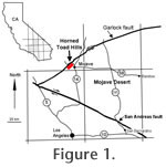
 The Horned Toad Hills are located in the northwestern edge of the Mojave Desert geologic province (Figure 1). The Garlock fault, which forms the northern boundary of this province, lies just north of the Horned Toad Hills and is interpreted as a transform structure that separates a domain of large-scale late Cenozoic extension on the north from more limited Cenozoic extension to the south in the Mojave Desert (Davis and Burchfiel 1973;
Christiansen and Yeats 1992). Evaluation of regional kinematic indicators in the western U.S. by
Hearn and Humphreys (1998)
agrees with earlier interpretations (Davis and Burchfiel
1973) that the Garlock fault accommodates the western dilation of the Great Basin and the northwest motion of the Sierra Nevada relative to the Mojave block. The Horned Toad Hills are located in the northwestern edge of the Mojave Desert geologic province (Figure 1). The Garlock fault, which forms the northern boundary of this province, lies just north of the Horned Toad Hills and is interpreted as a transform structure that separates a domain of large-scale late Cenozoic extension on the north from more limited Cenozoic extension to the south in the Mojave Desert (Davis and Burchfiel 1973;
Christiansen and Yeats 1992). Evaluation of regional kinematic indicators in the western U.S. by
Hearn and Humphreys (1998)
agrees with earlier interpretations (Davis and Burchfiel
1973) that the Garlock fault accommodates the western dilation of the Great Basin and the northwest motion of the Sierra Nevada relative to the Mojave block.
Sixty-four km of left-lateral displacement have been documented across the Garlock fault (Smith 1962).
Smith et al. (2002) presented evidence for 32-40 km of displacement since approximately 10 Ma and suggested initiation of motion at approximately 16 Ma based on an assumption of constant slip rate. On the basis of correlative volcanic units north and south of the Garlock fault,
Monastero et al. (1997) interpreted initiation of movement after 17 Ma, generally consistent with the initiation of major extension in the Death Valley system and supports a kinematic linkage.
Burbank and Whistler (1987) and
Loomis and Burbank (1988) have suggested a younger age (9–10 Ma) for initiation of slip on the Garlock fault. The average slip rate calculated by
Smith et al. (2002) (3.1-3.8 mm/yr) is about half that estimated by
McGill and Sieh (1993) for the Holocene (6-8 mm/yr) and by
Carter (1987) for the Pleistocene (7 mm/yr). Regardless of whether slip initiated in the early or middle Miocene, the Garlock fault was an active, left-lateral strike-slip fault during the deposition of the Horned Toad Formation. No offset equivalent of the Horned Toad Formation has been identified north of the Garlock fault. Facies relationships and sediment provenance suggest that the Horned Toad Formation was deposited in a localized basin.
The western Mojave Desert province includes Neogene sedimentary basins separated by low hills of Mesozoic granitic rocks, Tertiary volcanic and volcaniclastic rocks, and older metamorphosed sedimentary rocks. Neogene deformation of the Mojave block has been associated with crustal extension, strike-slip deformation, block rotation, and north-south compression.
Dokka (1989) recognized a number of structural domains within what he termed the Mojave Extensional Belt that reflect differing amounts and geometries of extension during the early Miocene. Since about 20 Ma, the western Mojave has been deformed along a series of sub-parallel, northwest trending right-lateral strike-slip faults with cumulative displacement of up to 40 km
 (Dokka 1983).
Kamerling and Luyendyk (1979),
Hornafius et al. (1986),
Golombeck and Brown (1988),
Ross et. al., (1989),
MacFadden et. al., (1990a,
1990b), Ross (1995),
Dokka and
Ross (1995) and others have presented paleomagnetic evidence for both
clockwise and counterclockwise rotation of fault-bounded crustal blocks in the
Mojave during the Neogene.
Kanter and McWilliams (1982) and
Plescia and Calderone (1986) have presented evidence for clockwise rotation of the Tehachapi Mountains north of the Horned Toad Hills between about 80 and 20 Ma. (Dokka 1983).
Kamerling and Luyendyk (1979),
Hornafius et al. (1986),
Golombeck and Brown (1988),
Ross et. al., (1989),
MacFadden et. al., (1990a,
1990b), Ross (1995),
Dokka and
Ross (1995) and others have presented paleomagnetic evidence for both
clockwise and counterclockwise rotation of fault-bounded crustal blocks in the
Mojave during the Neogene.
Kanter and McWilliams (1982) and
Plescia and Calderone (1986) have presented evidence for clockwise rotation of the Tehachapi Mountains north of the Horned Toad Hills between about 80 and 20 Ma.
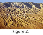
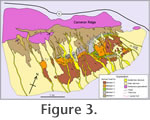
Mesozoic plutonic rocks represent the most common pre-Cenozoic lithologies in the vicinity of the Horned Toad Hills. The most important of these is the Cretaceous Cameron Granodiorite that forms the northeast-southwest trending Cameron Ridge, upon which the sediments of the Horned Toad Formation were deposited (Figure 2 and
Figure 3) (Ross 1980).
 Ross (1989), who referred to this unit as the "Granodiorite of Cameron," differentiated it from other granitoid units in the area with similar modal mineralogy by its coarse-grained texture, twinned feldspars, and striking salmon-pink K-feldspars at some outcrops. The Cameron Granodiorite is bounded on the north by the Garlock fault and was an important source terrain for sediments of the Horned Toad Formation. Ross (1989), who referred to this unit as the "Granodiorite of Cameron," differentiated it from other granitoid units in the area with similar modal mineralogy by its coarse-grained texture, twinned feldspars, and striking salmon-pink K-feldspars at some outcrops. The Cameron Granodiorite is bounded on the north by the Garlock fault and was an important source terrain for sediments of the Horned Toad Formation.
 Late Oligocene to Miocene volcanic and sedimentary rocks have been mapped at Soledad Mountain and in the Rosamond Hills south of the Horned Toad Hills.
Dibblee (1958) included the rocks exposed in the Rosamond Hills in the Tropico Group as a sequence of non-marine sediments and volcanic rocks overlying Cretaceous plutonic basement. The Tropico Group was subdivided by Dibblee into the Gem Hill Formation, the Fiss Fanglomerate, and the Bissell Formation.
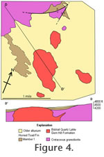
Dibblee (1963) described the early Miocene Gem Hill Formation as a stratified sequence of rhyolitic, lithic and lapilli tuffs, and tuff breccias with local facies of tuffaceous conglomeratic sandstone, volcanic conglomerate and siliceous shale, chert and limestone. The pyroclastic material of the Gem Hill Formation was derived from vents in the Soledad Mountain area that are now preserved as plugs of Bobtail Quartz Latite (Dibblee 1963). Bobtail Quartz Latite is also exposed in the western Horned Toad Hills where it apparently intrudes the Cameron Granodiorite and is overlain by sediments of the Horned Toad Formation (Member One) (Figure 4). Clasts of the Bobtail Quartz Latite are easily recognized in the coarser sediments of the Horned Toad Formation. Late Oligocene to Miocene volcanic and sedimentary rocks have been mapped at Soledad Mountain and in the Rosamond Hills south of the Horned Toad Hills.
Dibblee (1958) included the rocks exposed in the Rosamond Hills in the Tropico Group as a sequence of non-marine sediments and volcanic rocks overlying Cretaceous plutonic basement. The Tropico Group was subdivided by Dibblee into the Gem Hill Formation, the Fiss Fanglomerate, and the Bissell Formation.
Dibblee (1963) described the early Miocene Gem Hill Formation as a stratified sequence of rhyolitic, lithic and lapilli tuffs, and tuff breccias with local facies of tuffaceous conglomeratic sandstone, volcanic conglomerate and siliceous shale, chert and limestone. The pyroclastic material of the Gem Hill Formation was derived from vents in the Soledad Mountain area that are now preserved as plugs of Bobtail Quartz Latite (Dibblee 1963). Bobtail Quartz Latite is also exposed in the western Horned Toad Hills where it apparently intrudes the Cameron Granodiorite and is overlain by sediments of the Horned Toad Formation (Member One) (Figure 4). Clasts of the Bobtail Quartz Latite are easily recognized in the coarser sediments of the Horned Toad Formation.
|


